Ballarat Growth Areas
Ballarat is growing at a rapid rate and the City of Ballarat must plan for this growth. At current rates, Ballarat will have a population of more than 170,000 by 2041
Through both greenfield and infill supply, Ballarat needs to build over 1000 houses a year to meet this demand.
A Precinct Structure Plan (PSP) is a high level master plans that guide greenfield development to create whole communities. PSPs include layouts for roads, shopping centre, schools, parks, housing, employment and connections to transport.
A Development Contributions Plan (DCP) makes possible the timely delivery of infrastructure to new communities and funds major infrastructure projects such as drainage, roads, intersections and recreational open spaces.
Current Growth Areas
Alfredton West PSP
The Alfredton West Precinct Structure Plan (PSP) covers development of land in Lucas.
Relevant documents include:
The Ballarat West PSP
The Ballarat West PSP and DCP cover development of land in the current Ballarat West Growth Area.
There are two levies imposed under the Ballarat West DCP, the Development Infrastructure Levy (DIL) and the Community Infrastructure Levy (CIL).
Relevant documents include:
- Ballarat West Precinct Structure Plan Part 1
- Ballarat West Precinct Structure Plan Part 2
- Ballarat West Precinct Structure Plan Part 3
- Ballarat West Precinct Structure Plan Part 4
- Ballarat West Precinct Structure Plan Part 5
- Development Contributions Plan (DCP)
- Native Vegetation Precinct Plan
- Conservation Management Plan for the Growling Grass Frog
- Urban Design Framework for 331 Glenelg Highway Smythes Creek
Future Growth Areas
What are future growth areas?
Future greenfield land supply is required once land supply within the existing Ballarat West Growth Area diminishes. The Northern, North Western and Western Growth Areas have been identified as Ballarat’s preferred greenfield growth areas, capable of accommodating Ballarat's expected greenfield growth and housing demand beyond 2041.
Greenfield land or growth areas are former rural land areas that are identified to be developed for residential purposes. The land is typically undeveloped land and may have been previously used for agricultural or rural uses.
Strategic planning in Victoria seeks that local Council ensure 15 years of land supply is provided. Greenfield land is one element of land required to provide dwellings to service population growth.
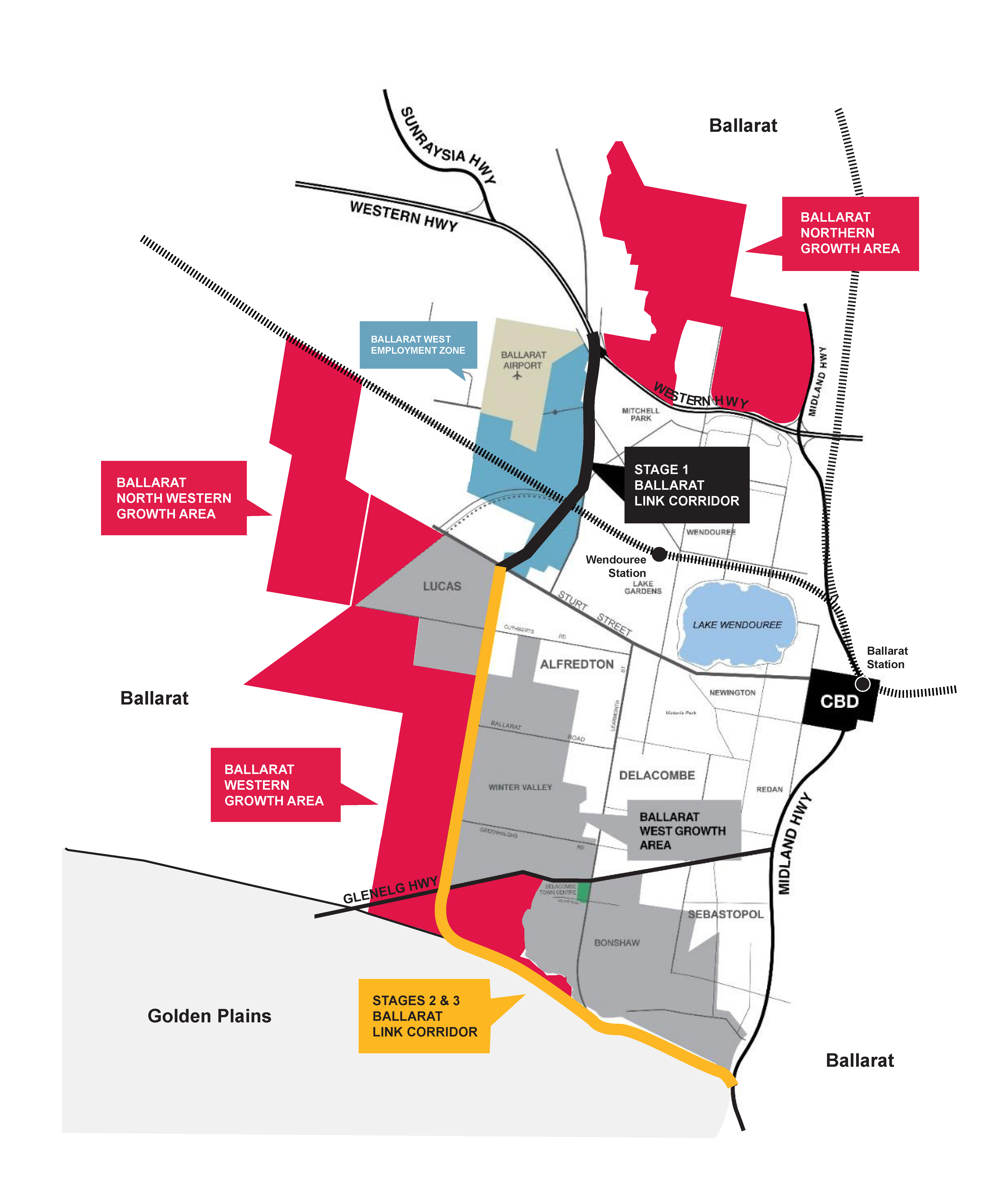
The three future growth areas
Western Growth Area
The Western Growth Area is expected provide around 14,000 dwellings at full development.
Key features of the area includes:
- Located in parts of Bunkers Hill, Lucas and Smythes Creek;
- Broadly bound by Dyson Drive, the Kensington Creek corridor and the Ballarat West Growth Area boundary to the east. Cuthberts Road to the north, Bunkers Hill to the west and the municipal boundary/ Bells Road to the south;
- Partially bound by and intersected by the Glenelg Highway; and
- Partially bound by the proposed Ballarat Western Link Road along its eastern boundary.
View or download the Western Growth Area Map
Northern Growth Area
The Northern Growth area is expected to accommodate up to 7,000 dwellings.
Key features of the area include:
- Located in parts of Mount Rowan and Miners Rest;
- Broadly bounded by Mount Rowan/ Cummins Road to the north, the Burrumbeet Creek Corridor / Delaney Drive to the west. the Western Freeway to the south and the Midland Highway to the east; and
- Adjacent to the Ballarat North Waste Water Treatment Plant & Water Reclamation Plant on the northern side of the freeway.
The Minister for Planning has rezoned the core area of the Northern Growth Area to Urban Growth Zone.
The VPA will prepare a PSP for the Northern Growth Area and consider extending the boundary to include the ‘expanded area.’
More information on the Ballarat North PSP can be found on the VPA website.
View or download the Northern Growth Area Map
North-Western Growth Area
The North-Western Growth area is expected to accommodate an additional 7,000 dwellings.
Key features of the area include:
- Irregular in shape and located to the west of Ballarat in parts of Lucas and Cardigan.
- Roughly bound by the railway alignment to the north, Dowling Road/ Ballarat-Skipton Rail Trail to the east. Cuthberts Road to the south and partially bounded by Draffins Road to the west.
- Broadly divided into two halves its middle by Remembrance Drive.
- Land to the south of Remembrance Drive is located adjacent to the Lucas Estate Alfredton West Precinct (i.e. east side of BallaratSkipton Rail Trail).
- Land to the north of Remembrance Drive is located adjacent to an existing Rural Living Zone (RLZ) land.
View or download the North-Western Growth Area Map
Status of the Future Growth Areas
A quarterly report was provided to council on 13 December 2023. This report provides project updates and can be found under Agenda Item 9.3 in December 2023 Council Meeting Agendas.
The report can be found under Agenda Item 8.3 in August 2023 Council Meeting Agenda - View Part 2 of the Council Meeting Agenda.
The Minister requested that the VPA prepare a high-level strategic review of Ballarat’s greenfield land and infill areas to inform future staging of residential growth and ensure adequate land supply. The VPA will prepare a review of Ballarat’s greenfield and infill land supply
The City of Ballarat is currently preparing a Growth Area Framework Plan for the Western and North Western Growth areas to inform appropriate staging and sequencing of residential growth
More information
For any questions about the Growth Areas, please contact staff in the Sustainable Growth team at ballaratwest@ballarat.vic.gov.au or call 03 5320 5500